Map of Meols and Leasowe
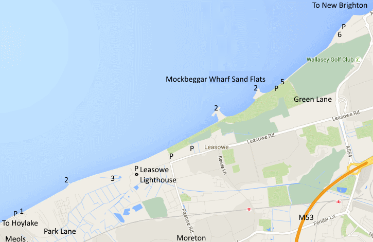
Map Ref: Leasowe Lighthouse SJ 252914
| Back to North Wirral Shore Map of Meols and Leasowe |
| Directions: Meols
can be approached either along the A553 from Hoylake centre or along
the promenade. Park anywhere along the promenade at Meols, the east
most point of the promenade is called Dove Point and there is a
car park by the slipway (1). Here you can walk towards Leasowe
Lighthouse through the sand dunes passing the first of three groynes
(2) which can hold good numbers of roosting waders at high tide. The
horse paddocks (3) inland of the coastal path along with adjacent reed
bed and duck pond are a particularly good spot for migrants. You can
also reach these horse paddocks along Park Lane, Meols, although
parking along here is very limited. There is good car parking at
Leasowe Lighthouse itself which you can approach either from Moreton
along Pasture Road or from the M53 and New Brighton along Leass owe
Road. Further car parks are at the end of Pasture Road and along
Leasowe Road. You can walk along the embankment all the way to New
Brighton promenade past two more groynes (2) but for those not wishing
to walk that far there is car parking on the sea front at the 'Gunsite'
(5) which is a favoured spot for sea watching during a gale using your
car as a hide, drive along Green Lane to this car park. Green Lane is
off the A554, just a short drive from junction 1 of the M53 following
signs to New Brighton. Continue along the A554 where you reach Harrison
Drive and the promenade, turn left at the roundabout to reach the
Lifeguard Station at Wallasey Shore (6) where there is plenty of
parking. Map Ref: Leasowe Lighthouse SJ 252914 |